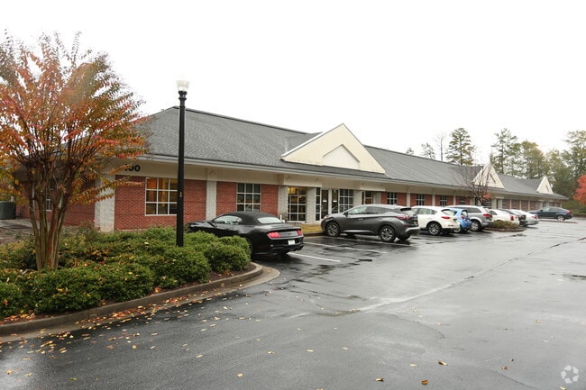
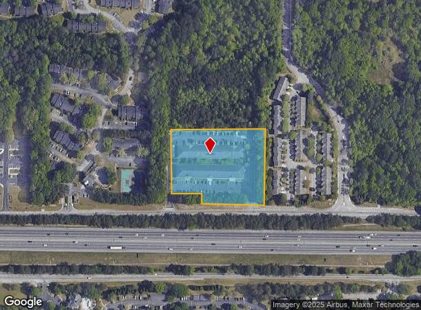
Property Record
5700 Hillandale Dr, Lithonia, GA 30058
NEARBY LISTINGS FOR SALE OR LEASE
Property Detail
5700 Hillandale Dr
Atlanta-Sandy Springs-Roswell, GA
Hillandale Partners Llc
16-056-01-003
300 X 40 X 145 X 305 X
Medicalbuilding
DeKalb
X
Georgia
13089C0158J
3
2025
3.40 AC
2025
I-20 East/Conyers
023319
Atlanta
32,348 SF
DEMOGRAPHICS near 5700 Hillandale Dr
1 Mile
3 Mile
5 Mile
2024 Total Population
14,557
73,833
162,568
2029 Population
14,501
73,375
161,562
Pop Growth 2024-2029
(0.38%)
(0.62%)
(0.62%)
Average Age
36
37
39
2024 Total Households
6,060
27,963
59,992
HH Growth 2024-2029
(0.53%)
(0.73%)
(0.70%)
Median Household Inc
$53,416
$57,699
$62,257
Avg Household Size
2.40
2.60
2.60
2024 Avg HH Vehicles
1.00
2.00
2.00
Median Home Value
$150,000
$170,279
$191,511
Median Year Built
1998
1991
1988
Nearby Places
Map Layers
Map Styles
 Street
 Aerial
- Restaurants
- Banks
- Shops
- Fitness
- Groceries
PUBLIC TRANSPORTATION
AIRPORT
Hartsfield - Jackson Atlanta International
DRIVE
WALK
Distance
Hartsfield - Jackson Atlanta International
29 min
19.2 mi
Freight Ports
Georgia Ports - Savannah
DRIVE
WALK
Distance
Georgia Ports - Savannah
280 min
242.0 mi
SALE & LEASE HISTORY
LISTING DATE
SALE/LEASE

Sep 24, 2016
For Lease
Nov 09, 2020
For Lease
Jan 30, 2019
For Lease
Nearby Properties
Address
Land Use
TOTAL SIZE
Lot Size
Zoning
Address
Land Use
TOTAL SIZE
Lot Size
Zoning
834,629 SF
59.49 AC
RM100
Address
Land Use
TOTAL SIZE
Lot Size
Zoning
208,447 SF
26.56 AC
RM100
Address
Land Use
TOTAL SIZE
Lot Size
Zoning
317,008 SF
37.05 AC
RM100
Address
Land Use
TOTAL SIZE
Lot Size
Zoning
764,622 SF
48.38 AC
M
Address
Land Use
TOTAL SIZE
Lot Size
Zoning
484,198 SF
31.10 AC
RM100
Address
Land Use
TOTAL SIZE
Lot Size
Zoning
271,666 SF
33.72 AC
RM100
Address
Land Use
TOTAL SIZE
Lot Size
Zoning
250,496 SF
14.35 AC
OI
Address
Land Use
TOTAL SIZE
Lot Size
Zoning
235,521 SF
15.36 AC
RM75
Address
Land Use
TOTAL SIZE
Lot Size
Zoning
118,007 SF
14.31 AC
Address
Land Use
TOTAL SIZE
Lot Size
Zoning
314,474 SF
24.04 AC
RM75
Address
Land Use
TOTAL SIZE
Lot Size
Zoning
81,537 SF
9.27 AC
C1
Address
Land Use
TOTAL SIZE
Lot Size
Zoning
249,506 SF
21 AC
RM100
Address
Land Use
TOTAL SIZE
Lot Size
Zoning
189,472 SF
30.90 AC
RM100
Address
Land Use
TOTAL SIZE
Lot Size
Zoning
217,925 SF
23.69 AC
RM100
Address
Land Use
TOTAL SIZE
Lot Size
Zoning
292,395 SF
19.65 AC
RM100
Address
Land Use
TOTAL SIZE
Lot Size
Zoning
1,810 SF
234.33 AC
RA8
Address
Land Use
TOTAL SIZE
Lot Size
Zoning
209,022 SF
16.22 AC
RM100
Address
Land Use
TOTAL SIZE
Lot Size
Zoning
814,943 SF
40.83 AC
M
Address
Land Use
TOTAL SIZE
Lot Size
Zoning
267,899 SF
47.90 AC
X
Address
Land Use
TOTAL SIZE
Lot Size
Zoning
283,988 SF
29 AC
RM100
Address
Land Use
TOTAL SIZE
Lot Size
Zoning
249,668 SF
16.76 AC
RM100
Address
Land Use
TOTAL SIZE
Lot Size
Zoning
287,681 SF
20.10 AC
RM100
Address
Land Use
TOTAL SIZE
Lot Size
Zoning
208,711 SF
34.59 AC
X
Address
Land Use
TOTAL SIZE
Lot Size
Zoning
198,140 SF
18 AC
RM100
Address
Land Use
TOTAL SIZE
Lot Size
Zoning
182,490 SF
12.46 AC
RM100
Address
Land Use
TOTAL SIZE
Lot Size
Zoning
218,152 SF
18.80 AC
RM100
Address
Land Use
TOTAL SIZE
Lot Size
Zoning
36,951 SF
8 AC
Address
Land Use
TOTAL SIZE
Lot Size
Zoning
168,610 SF
19 AC
M
Address
Land Use
TOTAL SIZE
Lot Size
Zoning
372,399 SF
12.63 AC
M
Address
Land Use
TOTAL SIZE
Lot Size
Zoning
138,876 SF
20 AC
RM100
The World's #1 Commercial Real Estate Marketplace
Connect with us
© 2026 CoStar Group
The information above has been obtained from sources believed reliable. While we do not doubt its accuracy we have not verified it and make no guarantee, warranty or representation about it. It is your responsibility to independently confirm its accuracy and completeness. Any projections, opinions, assumptions, or estimates used are for example only and do not represent the current or future performance of the property. The value of this transaction to you depends on tax and other factors which should be evaluated by your tax, financial, and legal advisors. You and your advisors should conduct a careful, independent investigation of the property to determine to your satisfaction the suitability of the property for your needs.